Borders are the boundaries that define a country’s territory and separate it from its neighbors. They can be natural, such as rivers or mountains, or artificial, such as walls or fences. Some countries have small borders, while others have extensive ones. In this article, we will explore the 10 longest borders in the world. The ten longest borders in the world are Canada-US Border, Russia-Kazakhstan Border, Argentina-Chile Border, China-Mongolia border, Russia-China border, India-Bangladesh border, Mongolia-Russia border, Bolivia-Brazil border, India-Pakistan border, and Mexico-United States border.
#1 Canada-US border: approximately 8,891 kilometers (5,525 miles), the longest border in the world
The longest border in the world is the border between Canada and the United States. This border is approximately 8,891 kilometers (5,525 miles) long. It stretches from the Pacific Ocean in the west to the Atlantic Ocean in the east.
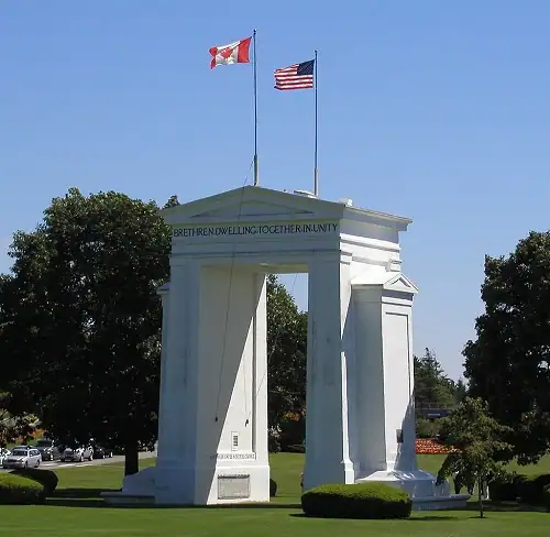
The border has two sections: Canada’s border with the contiguous US state of Alaska to its west and with the contiguous United States to its south.
Despite being the longest boundary in the world, the Canada-U.S. border is also one of the most peaceful. It is because the two countries share a strong diplomatic and economic relationship.
#2 Russia-Kazakhstan Border: approximately 7,644 kilometers (4,750 miles), 2nd longest boundary in the world
The second-longest border in the world is the border between Russia and Kazakhstan. This border is approximately 7,644 kilometers (4,750 miles) long. It starts at the Caspian Sea in the west. The border runs through a variety of terrain, including mountains, forests, and deserts. The Altai Mountains form the easternmost part of the border. The border also passes through the Eurasian steppe and Lake Botkul.
The Russia-Kazakhstan Border holds the distinction of being the longest continuous international border globally and ranks as the second longest in total length, following the Canada-United States border.
The largely undeveloped border has only a few small towns and border posts along its length.
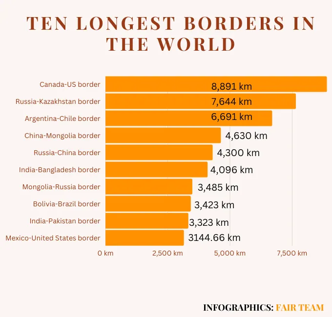
#3 Argentina-Chile Border: approximately 6,691 kilometers (4,163 miles)
The third-longest border in the world is the border between Argentina and Chile. This border is approximately 6,691 kilometers (4,163 miles) long. It runs through the Andes Mountains. The border is largely uninhabited and unpatrolled. It has only a few small towns and border crossings. The border is also notable because it runs through some of the most beautiful and remote landscapes in the world, including the Patagonian Desert and the Torres del Paine National Park.
#4 China-Mongolia border: approximately 4,630 kilometers (2,880 miles)
The China-Mongolia border is the fourth largest boundary in the world, stretching approximately 4,630 kilometers (2,880 miles). The border runs from the Altai Mountains in the west to the Greater Khingan Mountains in the east. The Altai Mountains are located in the northeastern corner of China and the southwestern corner of Mongolia. The Greater Khingan Mountains are located in the northeastern corner of Mongolia.
The border was first established in the 17th century. The border was established as part of the Treaty of Nerchinsk, which was signed by China and Russia. The treaty was signed to end the conflict between the two countries over the control of the Altai Mountains. With the Communist Party coming to power in China in 1949, relations between China and Mongolia gradually improved. On December 26, 1962, the two countries signed a treaty to define their common frontier. Subsequently, from 1963 to 1964, a comprehensive border demarcation took place, leading to the finalization of a detailed set of maps and the signing of a final treaty on June 30, 1964.
The China-Mongolia border serves as a vital trade route, facilitating substantial economic activity between the two nations. China holds the position of Mongolia’s largest trading partner, and the bilateral trade volume between them reaches billions of dollars annually. With 14 border crossings available for imports and exports, the border plays a critical role in facilitating the flow of goods and fostering economic cooperation.
#5 Russia-China border: approximately 4,300 kilometers (2,672 miles), 5th longest boundary in the world
The Russia-China border is one of the longest boundaries in the world, stretching approximately 4,300 kilometers (2,672 miles) across the northern part of Asia. The border is notable for its vast size, diverse geography, and complex history.
The history of the demarcation of the border between China and Russia spans several centuries, starting from the 17th century. The border disputes emerged during the Qing Dynasty in China and the expansion of the Russian Empire. Various treaties, negotiations, and conflicts marked the efforts to define the border, including the Treaty of Nerchinsk in 1689 and the Treaty of Kyakhta in 1727. Subsequent agreements, such as the Treaty of Aigun in 1858 and the Treaty of Peking in 1860, further delineated the border. In modern times, negotiations continued after the establishment of the Soviet Union and the People’s Republic of China. The final demarcation was accomplished with the signing of the Treaty on the Russian-Chinese State Border in 2004, solidifying the border’s alignment and promoting peaceful relations between the two nations.
In recent years, the Russia-China border has become the focus of increased attention and investment as China seeks to expand its economic influence across Asia and Russia seeks to diversify its trade partnerships. The two countries have launched a series of initiatives, including the Belt and Road Initiative and the Eurasian Economic Union, aimed at strengthening economic ties and improving infrastructure links across the region.
#6 India-Bangladesh border: approximately 4,096 kilometers (2,545 miles); 6th longest boundary in the world
The India-Bangladesh border, also known as the International Border (IB), is the sixth longest border in the world, stretching approximately 4,096 kilometers (2,545 miles) across the eastern part of the Indian subcontinent. The border is significant for the close cultural and economic ties it creates between India and Bangladesh, two countries that share a rich history and common heritage.
The India-Bangladesh border came into being in 1947, following the partition of India and the creation of Pakistan.
#7 Mongolia-Russia border: approximately 3485 kilometers (2165.47 miles)
The seventh longest boundary in the world is the border between Mongolia and Russia. This border is approximately 3485 kilometers (2165.47 miles) long. The largely undeveloped has only a few small towns and border crossings. It separates two of the world’s largest countries and some of the world’s most unique cultures.
The Mongolia-Russia border encompasses a diverse range of geographical features, starting from its western tripoint with China, located approximately 100 kilometers (62 miles) east of the China-Kazakhstan-Russia tripoint. From there, the border extends in a broadly northeast direction through the majestic Altai Mountains.
As the border progresses, it reaches the vicinity of Mongolia’s Uvs Lake, where it briefly cuts into the lake’s northeastern corner, placing that portion of the lake within Russian territory. Continuing eastwards, the border follows a series of overland lines, angled slightly to the southeast. Along this section, it traverses Lake Tore-Khol, crossing the water body as it advances. Next, the border turns northward, passing through the Ulaan Taiga mountains, forming a broad arc through the Sayan Mountains surrounding Mongolia’s beautiful Lake Khövsgöl.
Continuing eastwards, the border arches broadly in a northern direction, briefly utilizing the Chikoy River as part of its delineation. It then turns southward in two long arcs before curving northeast and eventually east, skirting south of Russia’s Lake Barun-Torey. Finally, the Mongolia-Russia border terminates at the eastern Chinese tripoint, marking the end of its extensive journey through diverse geographical regions.
Tripoints at the Mongolia-Russia border
The Mongolia-Russia border boasts two significant tripoints at its eastern and western ends, where it intersects with the China-Russia and China-Mongolia borders, respectively. These tripoints mark the convergence of the three nations and hold strategic importance in defining the boundaries and fostering diplomatic relations in the region. The exact location of these tripoints was established through a special trilateral agreement signed on January 27, 1994, in Ulaanbaatar. This agreement was based on earlier bilateral treaties between Mongolia, Russia, and China, outlining the terms and conditions for the determination of these tripoints.
#8 Bolivia-Brazil border : approximately 3423 kilometers ( 2126.95 miles)
The Bolivia-Brazil border is one of the longest land borders in South America, stretching over 3423 kilometers or 2126.95 miles. It begins in the northwest at the tri-border with Peru and runs south along the eastern edge of Bolivia, through the states of Rondonia, Mato Grosso, and Mato Grosso do Sul in Brazil, before ending at the Paraguay-Brazil border in the southeast.
This border is famous for its vast and diverse landscape, including the Amazon rainforest, the Pantanal wetlands, and the Andean mountains. It is also an important transit route for trade between Bolivia and Brazil, as well as a significant area for illegal activities such as drug trafficking and smuggling.
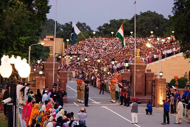
# 9 India-Pakistan border: approximately 3323 kilometers (2064.81 miles), 9th longest border in the world
The India-Pakistan border is one of the most contentious borders in the world. It stretches over 3323 kilometers or 2064.81 miles, dividing the Indian subcontinent into two countries. The border is heavily militarized, with both India and Pakistan stationing troops, tanks, and artillery along the line. The India-Pakistan border has three sections:
The Line of Control (LoC)
The LoC is the de facto border between India and Pakistan in the Kashmir region. It was established in 1972 as part of the Simla Agreement, which was signed by India and Pakistan to end the Indo-Pakistani War of 1971. The LoC is not internationally recognized as a border, but it is effectively the border between India and Pakistan in the Kashmir region.
The International Border (IB)
The IB is the internationally recognized border between India and Pakistan. It was established in 1947 as part of the Partition of India, which was the division of British India into two independent dominions: India and Pakistan. The IB runs from the Rann of Kutch in the west to the Himalayas in the east.
The Actual Ground Position Line (AGPL)
The AGPL is the line that separates the Indian and Pakistani armies in the Siachen Glacier region. It came into being in 2003 as part of the Karachi Agreement. The two countries signed the agreement to reduce tensions in the region. The AGPL is not an internationally recognized border. However, it is effectively the border between India and Pakistan in the Siachen Glacier region.
The border is a site of frequent clashes between the two countries. Tensions have been high since the partition of India in 1947. The border has also been the site of several wars between India and Pakistan. The major wars include the 1965 war and the 1999 Kargil conflict. Despite efforts to resolve the longstanding dispute over the region of Kashmir, the border remains a source of conflict between the two nations.
#10 Mexico-United States border: approximately 3144.66 kilometers (1954 miles), the 10th longest border in the world
The Mexico-United States border is one of the busiest and most controversial borders in the world. It stretches over 3144.66 kilometers or 1954 miles. It separates Mexico from the United States. The Mexico- US border runs from the Pacific Ocean in the west to the Gulf of Mexico in the east.
The border is a site of intense political and social debate, particularly with regard to issues of immigration, drug trafficking, and trade. It has also been the site of numerous protests and acts of civil disobedience. Activists also call for an end to border militarization and increased support for immigrant rights. Despite these challenges, the border remains an important economic and cultural link between the two countries.
FAQs
Which country has the longest border in the world?
Canada and the US share the longest land border in the world, which stretches for 8,891 kilometers (5,525 miles).


The Russian-Kazakhstan border doesn’t extend from the Artic Ocean. It’s nowhere near the Artic Ocean.
Thank you for pointing out the mistake. We are making the correction. Thank you again