Bangladesh lies on the confluence of three major rivers of Asia, the Ganges, the Brahmaputra and the Meghna. The watershed basins of these rivers cover the center, north and northeastern part of South Asia, and the Great Himalayan Range. The catchments area of the Ganges, Brahmaputra and Meghna basins are about 1,761,300 sq km in total, of which 120,400 sq km (7% only) lies in Bangladesh. As those rivers fall in the Bay of Bengal and go through Bangladesh, they form a country of rivers via their distributaries. More than 1,000 rivers can be traced during monsoon and floods, though only about 200 rivers now flow round the year. Bangladesh has 57 common rivers that originate in India, Nepal, China, Bhutan and Myanmar, comprising of the three major rivers and their tributaries. Those common rivers are being prevented of their historical flows by upland countries, particularly by India and China, through dams and barrages, causing severe environmental and socioeconomic impact, and destroying animal habitats and plants in Bangladesh.
The Bengal basin stretches from the Chotonagpur Highlands of Central India to the Lushai Hills of the India-Myanmar border, from the Himalayas to the Bay of Bengal. This basin covers the whole of Bangladesh, Bhutan, West Bengal, and the seven northeastern states of India. Bangladesh being at the center of this is mostly the flood plain of two major rivers, the Ganges and the Brahmaputra. A part of Bangladesh to the north, east, and southeast is hilly, but also has plains of the Meghna River and some other independent rivers. The Bengal plain is divided mainly into two countries, India and Bangladesh (this division, though, was a manmade political one). Thus, we find rivers originating in Bhutan that travel through India then pass through Bangladesh (the Dharla River). Other rivers originate in Bangladesh, travel through India, then re-enter Bangladesh (Atrai, Punarbhaba, Betna). The Mahananda and Dahuk Rivers enter Bangladesh and leave to meet the Ganges in India.
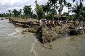
Hundreds of rivers, big and small, crisscross the land of Bengal Plain from north to south towards the Bay of Bengal. But morphologically, the Bengal basin can be divided into 4 major river systems: 1) the Ganges River 2) the Brahmaputra River 3) the Meghna River and 4) the southeastern hilly rivers. These systems have major, medium, and minor rivers as tributaries and distributaries. The source of surface water in Bangladesh is rainfall and the stream flow coming in from outside the country. With an average annual rainfall of about 2300mm, it generates about 276 Million-Acre Feet (MAF) of water locally. Water coming from outside through stream flow is estimated at about 818 MAF annually. Thus, the total water resource generated in this country is about 1094 MAF or 1350 Billion Cubic Meter (BCM) per year. However, most of this huge resource is drained down to the Bay of Bengal, to form brackish and sweet water mixed ecosystems in the estuaries. The water brings down about 1400 million tons of silt per year through Bangladesh and deposit over the flood plains and in the Bay of Bengal.
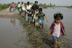
The surface water resource of this country is essential for organisms, aquatic flora and fauna, navigation, agriculture, etc. It is also necessary for keeping alive the distributaries in the delta, and maintaining the brackish water ecosystem along the sea, on an annual cycle. The groundwater system of Bangladesh called the Dupi Tila aquifer gets annual recharge from the surface water which is crucial for maintaining the environmental balance of the total region, particularly in the estuaries to the south, and at the mouth of the rivers. The breeding of Hilsa in the estuaries and shrimps along the continental shelf depends on the sweet water flow from the uplands. Along the coastlines the ecosystem of Bangladesh varies in character from the west to the east depending on the availability of sweet water. Some fishes indigenous to Satkhira rivers are unavailable to other parts of the coastline because water quality changes.
India started intervening in the Ganges River flow since the British era by building dams and barrages over the river for the production of hydroelectricity and irrigation. This obstructed the flow of the Ganges’ major tributaries like the Jamuna, Ramganga, Sarda, Ghagar, Gandak, Kosi, Chambal, Betwa, Son, and others. The Farakka Barrage was the final onslaught resulting in the withdrawal of the residual flow coming towards Bangladesh. Every river has a character of flood flow and base flow. The flood flow is the highest quantity of water discharged when excessive rainfall occurs in the basin. The base flow is the discharge coming from springs and drainage water from the lowlands. The base flow gradually reduces after monsoon and reaches its lowest point in winter. Some rivers receive snowmelt water of the Himalayas at the start of spring after which their flow rises. But rivers coming from arid regions have their base flow go lower in spring and summer, until monsoon returns. The Ganges used to get snowmelt water in the past but that water was diverted to areas of Uttar Pradesh and Bihar for irrigation. Whatever residual flow of the base flow of the Ganges came towards Bangladesh was diverted to the Hoogly River through a link canal from the Farakka Barrage.
China and India have extensive plans to build dams over the Brahmaputra River and its tributaries and the two countries have executed or are in the process of executing some of the projects. They have similar ongoing projects on the tributaries of the Meghna River. In addition, they have a programme to interlink the rivers of the Brahmaputra Basin with the rivers of the Ganges Basin in the name of India’s River Linking (IRL) Project. This IRL Project wants to divert a large amount of base flows of the rivers in the Brahmaputra Basin towards the arid regions of Rajasthan, Gujarat, and southern Indian states. This will have extremely disastrous effects on Bangladesh. India has already built dozens of dams in the Teesta Basin and is diverting its residual flow towards the Ganges Basin, creating an obstruction, namely the Gazaldoba Barrage. Teesta is a tributary of the Brahmaputra River, so one could say that India has already executed a major part of the IRL Project. Thus, India is taking away our historical rights on the rivers, upon which humans, animals, plants, agriculture, and the economy depend. However, whenever any diplomatic effort is made by our government to mitigate this issue, India says, ‘We will not do anything that will harm Bangladesh’. And now, China has completed its first hydropower dam on the Brahmaputra Basin at Zangmu in Tibet to generate 510MW hydroelectricity.
The Brahmaputra River originates in the Manos Sarovar, located between the Himalayas and the Kailash Range in Tibet. At its origin is the Yarlung-Tsangpo River. It flows to the easterly direction, parallel to the Himalayas, for about 1600 kilometers; then turning south it breaks through the Himalayas in the name of Dihang/Siang Gorge, to enter the Arunachal Pradesh of India. At Sadia, it touches the Assam plain and meets the Dibang and Lohit Rivers on its left bank. From this point, the combined flow becomes the 24Brahmaputra1 River. The District Gazetteer, Mymensing 1978, states that, (page 7), the Tsangpo River broke through the Himalayas in 1780. Before that, this river in Assam was known as the Lohit River.
From Sadia in Tinsukhia District of Assam, the Brahmaputra River flows southwest, and travels for about 800 kilometers inside India to reach the Bangladesh-India international borderline. On its way, it meets with several important tributaries including the Subansiri in Lakhimpur District, the Bhareli in Tezpur District, the Manos in Barpeta District and the Sankosh in Dhubri District on its right bank, and the Burhi Dihing in Tinsukia District, the Dhansiri in Golaghat District and the Kopili in Nowgaon District on its left bank. The Brahmaputra River then enters the Kurigram District of Bangladesh.
Inside Bangladesh, the Brahmaputra River meets with other important tributaries e.g. the Gadadhar (Sankosh), the Dudhkumar, the Dharla and the Teesta rivers on its right bank in the Kurigram District. The important tributary that falls on its left bank inside Bangladesh is the Jinjiram River, in Kurigram District. Leaving Kurigram District, the Brahmaputra1 River starts to distribute its flow to its deltaic floodplain. Its major distributary is the Jamuna1 River on its right bank. It carries almost 80% of its water during monsoon. The other distributaries on its right bank are the Jhenai, the Bangshi, the Suti and the Sirkhali rivers in Jamalpur District. Near Toke of Gazipur District, the Brahmaputra leaves another major distributary called the Sitalakhya River from its right bank. This river carries 60% of the Brahmaputra flow from Toke. The Brahmaputra River with its remaining water finally falls in the Meghna River, south of Bhairab Railway Bridge.
The Rennell’s Map of 1779 shows the Brahmaputra River’s main flow passing through the Old Brahmaputra River course. The Jamuna River was shown a distributor on its right bank. The District Gezetteer, Mymensing mentions 3 rivers named the Daokoba, Konai and Salangi. These rivers vanished after the 1787’s great flood which changed the Brahmaputra River’s course towards the Jamuna. Now the offtake of Old Brahmaputra gets silted in winter. The Narasunda River a major distributary, and other distributaries from its left bank (the Kharia, Sowai, and Kachamatia) are now dead. The Old Brahmaputra River leaving its main flow towards the Jamuna River remains silt carrying, flooding, and eroding. Jamalpur and Mymensing are located on its right bank. Kishoreganj is located on the bank of Narasunda River. The total length of the Old Brahmaputra River from Char Rajibpur to Bhairab is about 240 km. Its important water level measuring stations are at Mymensing and Toke.
India seems to have withdrawn its position to oppose Chinese moves being justified by the explanation that it is a ‘Run of the River’ dam, that does not harm the river flow downstream (The Hindu, 17 May 2013). But the reality is that India, too, says that the dams built on the Teesta River are ‘Run of the River’ dams. This is mere bluff, as ‘Run of the River’ dams cannot produce hydroelectricity round the year unless the base flow is restricted and stored in the dam reservoir. India’s stand is similar to that of China, which reveals their rampant onslaught on the Brahmaputra and their tributaries. Both the countries have several ongoing projects that serve to restrict the natural flow of these rivers. The dams in Sikkim in India are doing this, and Teesta River’s flow has diminished. The Bangladesh government hasn’t done its homework in order to show the adverse effects in Bangladesh because of water withdrawals upstream.
This transfer of water from the Brahmaputra basin to the Ganges basin is totally unacceptable. The onslaughts on the Brahmaputra River by China are also not acceptable. These acts violate the International Convention on Non-navigational uses of Watercourses of 1997 in force since 17 August 2014. Bangladesh, though voted in its favor in the General Assembly of the UN in 1997, is yet to ratify this convention officially. India did not vote and China opposed.
Relevant: WHY IS CHINA INTERESTED IN THE TEESTA RIVER?
Water can be used on an equitable basis where the minimum historical flow is maintained for the life of the river, and does not cause harm to other states. The watercourse convention Article 7.1 has an obligation that states, ‘Watercourse States shall, in utilizing an international watercourse in their territories, take all appropriate measures to prevent the causing of significant harm to other watercourse States.’ Article 7.2 says, ‘Where significant harm nevertheless is caused to another watercourse State, the States whose use causes such harm shall, in the absence of agreement to such use, take all appropriate measures, having due regard for the provisions of articles 5 and 6, in consultation with the affected State, to eliminate or mitigate such harm and, where appropriate, to discuss the question of compensation.’
The writer is the Chairman of Institute of Water & Environment.