Bangladesh has 57 transboundary rivers1 and many smaller streams shared with India. Except a few, all those rivers originate in the Indian Territory, and pass through Bangladesh to their final outfall, the Bay of Bengal. All those rivers flow at full capacity during monsoon but become lean during winter to summer. Withdrawal of water from major rivers in India such as the Ganga, the Tista, the Mahananda, and others for irrigation in dry months, turns their downstream lean in Bangladesh. India’s river interlink project will exacerbate the problem and bring disaster to the lower riparian Bangladesh.
Indian River Basins
The major river basins of India are the Brahmaputra, the Barak, the Ganga, the Mahanadi, the Godavari, the Krishna, the Cavery, the Tapti, the Narmada, and the Indus Rivers. The Indus River basin is shared with Pakistan, the Ganga basin with Nepal and Bangladesh, the Barak basin with Bangladesh, and the Brahmaputra basin with Bangladesh, Bhutan, and China.
India has the highest annual rainfall of about 3500 mm to the west of the Western Ghats Mountains and to the northeastern state of Arunachal. The average rainfalls on major river basins are, Brahmaputra 2500mm, Barak 2000mm, Ganga 1500mm, Godavari 1100mm, Krishna 800 mm, Cavery 1000mm, Narmada/Tapti 1000mm, Sabarmati 900mm and Luni less than 300 mm. Bangladesh lies on the downstream areas of the Ganga, the Brahmaputra, and the Barak river basins. The average annual rainfall in Bangladesh is about 2300 mm.
Indian Rivers Interlink proposal
After independence, India and Pakistan were locked in disputes over sharing waters of the Ganga and the Indus Rivers. The Indus Waters Treaty was signed between Pakistan and India in 1960 to solve disputes in the western sector. But due to political turmoil and the War of 1965, sharing of Ganga waters remained unresolved until 1996. India arrived with a plan2 in 1972 to interlink its rivers from north to south, for water resources transfer and navigation. India completed the Farakka Barrage in 1975 and took control over the flows of Ganga River towards Bangladesh.
Before arriving at a long-term understanding of sharing the Ganga waters with Bangladesh, the Indian government proposed a link canal from the Brahmaputra River to the upstream of the Farakka Barrage of the Ganga River through Bangladesh, to divert the Brahmaputra water flow for flow augmentation. This proposal was rejected by Bangladesh as unacceptable, as it would affect major human displacement, huge land loss, and colossal damage to the estuarine and marine environment towards the mouth of the Brahmaputra River.
The proposal for interlinking rivers in India resurfaced again after the Bharatiya Janata Party (BJP) gained power in the center, winning the Lokshabha election of 1999. This time the proposal was very particular, to transfer the excess water from the northeastern states to the drought-hit western and southern states of India. The proposal gained quick momentum as it got the support of the Hindutva lobby in the government.
The Hindutva Lobby
The Bharatia Janata Party (BJP) led the coalition government in power in India in 1999. A merger of several parties, mainly the Jan Sangh Party, formed the BJP. The Jan Sangh stalwarts were Hindu revivalists, having strong links with the Hindu Mahasabha and Hindu militant organization the Rashtriya Sayangsebak Sangh (RSS). Thus the government was very much influenced by its background connections and promoted the philosophy of Hinduttya. It is reported that the Chairman of the Task Force of the Rivers Interlinking Project, Suresh Prabhu was a strong sympathizer of the Hindutva Lobby.
Before the British colonial rule the people of Hindustan used to call themselves ‘Hindi’ irrespective of their religion. The `Divide & Rule’ policy of the British Raj created enmity between the Muslims and non-Muslims; the non-Muslims altogether started identifying themselves as ‘Hindu’s. The Hindutva ideology of BJP is that every citizen of India should call themselves ‘Hindu’, to express their integrity. It is known that the Hindutva promoters have taken the Indian rivers interlink as a tool to achieve their goal in the name of integrity of the country.
South Indian Lobby
The Rivers Interlinking Project in India is supposed to benefit the people of West and South India. The average annual rainfall there is about 500mm and 900mm. Godabari, Krishna and Cavery are the major river basins in South India. The states Maharashtra and Karnataka lie in the upstream and Andhra Pradesh and Tamil Nadu lie to the downstream of those river basins. Those four states are bitterly interlocked in disputes on sharing the scarce resources of waters in their common rivers.
It appears that the people in West and South India are in favor of this project on obvious reasons. Water of any quantity if arrives from other sources shall ease their tensions between states. Indian the then President Dr. APJ Abdul Kalam who hails from south, is among the top listed intellectuals who admires and proposes to implement the project under SAARC umbrella.
Effects of the Indian Rivers Interlink Project
1. The Brahmaputra Valley
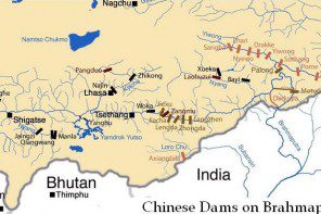
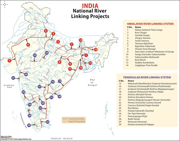
The Rivers Interlinking Project in India starts from the Brahmaputra River valley in Assam. To transfer waters from this region shall need to construct a diversion barrage over the river at somewhere near Goalpara or Guahati, and shall need to lift water about 100 meters to pass through North Bengal. So it is very likely that such interventions shall affect badly to the local environment. Moreover, huge diversion canals (# 1 & 14) to be constructed shall cause huge land loss and human displacement, and damage to the wildlife sanctuary of Manas in the Kokrajharh districts.
The proposed hydroelectricity project over the Dihang Gorge in Arunachal Pradesh could not be implemented so far due to border disputes with China. In Assam, the Brahmaputra River basin has high rainfall and flooding, so needs quick drainage. So any unnatural intervention on its flow path there shall obstruct its flood flow. Thus the Rivers Interlinking Project is not likely to benefit the people of Assam anyway.
2. North & West Bengal
Diversion of waters from the Brahmaputra valley shall need to excavate a long and wide canal over the Kuchbehar, Jalpaiguri and Siliguri districts of North Bengal in India. This canal shall intercept water flows of the Manas, Sankosh, Dudkumar, Dharla, Tista and Mahananda rivers on the Duars & Tarai plains. The project shall eat up huge land and cause displacement of people. The route of this canal shall be against the natural drainage slope at places, so shall be clogged by deposit of sand, and shall incur huge maintenance cost. Thus, the Rivers Interlinking Project is not likely to benefit the people of North Bengal anyway.
The West Bengal people are to be affected badly, as the Indian government plans to interlink the rivers (Canals # 10 & 11) through the coastal plains of West Bengal, Orissa and Andhra Pradesh. It proposes the transfer of sweet water to the Sundarbans (Canal # 13); but people have to face loss of land and displacement by digging those canals over them. Thus, the Rivers Interlinking Project shall cause immense suffering and disaster of no limit.
3. Bihar Plains
The Rivers Interlinking Project canals from the Brahmaputra valley shall have to pass through the Bihar plains of Tarai and Trihut to reach the Ganga River. The canals on their way shall eat up huge fertile land and cause displacement of people. Thus the Project is not likely to benefit the people of Bihar plains anyway.
Bihar is already full with waters of the Koshi and the Gandak Rivers. For environmental reasons it needs unrestricted flow of the Ganga River which is being restricted in its upper tributaries for irrigation diversions. Thus, augmentation of the Ganga flow at Farakka with a loss of huge land and sufferings of the people cannot be the proper alternative, but shall instigate more withdrawal in their upper tributaries.
4. Crossing the Bindhya Range
The main hurdle of the Rivers Interlinking Project to transfer water to the south shall be crossing the Bindhya and the Mahakal Ranges. Water has to be lifted 1 kilometer up or canal has to be dug 1 kilometer deep to cross these highlands. But India plans to divert the Ganga waters through the Rajsthan deserts and through the coastal plains of West Bengal and Orissa. The western route shall encounter huge travel lengths through very adverse weather and physical conditions. The eastern coast route shall devour valuable agricultural lands giving no benefit to the locals. Moreover it is anticipated that huge conveyance loss through the transfer routes shall make the project unsustainable.
5. The Godavari & the Krishna
The Rivers Interlinking Project if implemented shall first reach and augment the water flows of the Godabari basin and then the Krishna basin. Until now, these two rivers are independently managed and have little disputes between the co-riparian states of Maharashtra, Karnataka and Andhra Pradesh. The Rivers Interlinking Project shall change the scenario and shall invite unforeseen disputes and complications at the cost of spending huge money and land loss.
6. The Cavery Waters
The states of Karnataka and Tamil Nadu have a historical dispute over their share of Cavery waters. The Rivers Interlinking Project is to link Pennar River and the rivers of Kerala. These plans are likely to complicate the situation further in the region.
Bangladesh Scenario
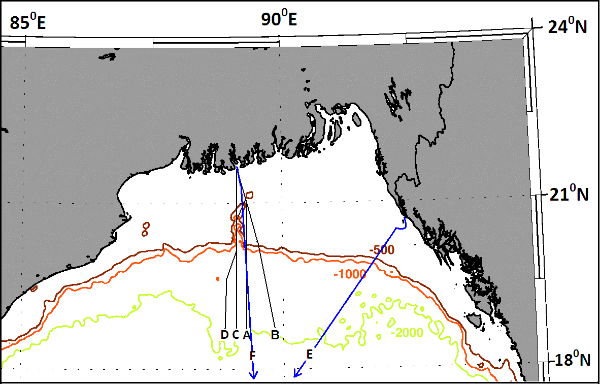
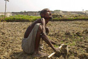
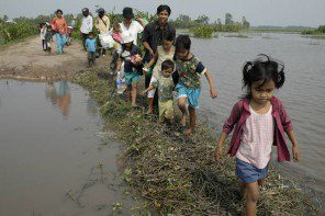
The effect of diversion of the Brahmaputra water in India shall bring catastrophic disaster over Bangladesh. In absence of the present lean period flow coming from the Brahmaputra River (75% of the dry season flow), the salinity from the sea shall rush up deep into the country. It shall damage the whole cropping system and cause bad effects to the flora and fauna and human living. The incursion of salinity shall affect more than half of the country including the haor areas to the northeast, and the lowlands of central region. Many of the distributaries of the Brahmaputra River shall dry up causing harm to agriculture, navigation and human living.
The Ganga Meghna estuary shall face colossal damage to its flora & fauna by the changed annual flow of sweet water from the upstream. The migration and spawning of Hilsa and other fishes shall be jeopardized.
The Making of a Disaster
The Indian National Water Development Agency (NWDA) plans to implement the project of interlinking 37 rivers by digging 600 miles of canals and creating hundreds of reservoirs over a 43 years time span. The Rivers Interlinking Project as contemplated by the Indian planners and its government appears to be a Disaster in the Making.
About 173 Billion Cubic Meter waters to be diverted from the Brahmaputra River. Its Himalayan Stretch has Links 14, Big Dams 9, & Canal length 6099 km. Its Southern Stretch has Links 16, Big Dams 27, & Canal length 4777 km. An expert on water resources wrote3, the Central Water Commission found the plan technically feasible, but not economically viable. The costs were believed to have been underestimated while benefits were likely to be reduced by seepage and other losses en route (NWDA, 1988).
The people of Bangladesh as well as the people of Assam, Bihar, West Bengal and Uttar Pradesh should opposed the Rivers Interlinking Project of India. The project is a clear violation of 1) the Helsinki Rules on the uses of the waters of international rivers 1966, and 2) the UN water convention of the non-navigational uses of international watercourses 1997.
Transfer of waters from one basin to another has always been considered as disastrous to the environment and to humanity. Moreover, such efforts are against the natural course of the rivers, so cannot be cost-efficient or sustainable in the long run. It may be mentioned here that, a project to link the Siberian Rivers in Central Asia to the drought-hit river basin of Sir Darya was abandoned by the Soviet government facing such problems.
References
1. Water Resources Management in Bangladesh.
M. Inamul Haque, 2008, Pages 349-352.
2. Waters of Hope, B.G. Verghese. 1990. Page 331.
3. Ibid. Page 331.
M Inamul Haque, Chairman, Institute of Water & Environment
minamul@gmail.com