Introduction
Building state of the art ports and taking strongholds for monitoring the strategic locations and shipping the resources by cutting the distances have been a major feature around the Indian Ocean in the 21st century. The high politics around the two ports, Gwadar and Chahbahar, added a new dimension in the Indian Ocean security architecture. Both the ports are called the New Silk Road ports with the emerging context of new great game. No other deep sea ports got so much attention before like these two in our time.
The rise of China and India and their competition for regional supremacy makes the regional chessboard more complex than before. The Asian tiger’s fierce competition for possessing vital locations and securing the energy routes manifests through increasing the naval presence in the Indian Ocean and seeking for alliances.
Pakistan’s quest for strategic depth further to the South west motivates it to go for building port in Baluchistan. Karachi port is always vulnerable for Pakistan for its geographical proximity to India. In the past, in fact in 1971, Pakistan’s Karachi port faced naval blockade by the Indian Navy during the war between West and East Pakistan and was endangered again during the Kargil war in 1999. The Gwadar port removed this vulnerability and added a new crown for Pakistan’s Navy to compete with other regional navies.
On the other hand, the key factor that motivates India to go for building port in Iran, by not challenging the US in fundamental ways, is to counter Pakistan and China’s strategic ambition and making its own way to new Silk Road politics. This port is very important for India-Iran and India-Afghanistan partnership, landlocked Afghanistan’s access to this port and west’s effort of encouraging other countries for isolating Iran.
Both Pakistan and Iran are trying to connect these two ports through road networks and Iran has already agreed to supply electricity in Gwadar port. If the ports can work effectively in the complex Eurasian strategic environment then we will see a new channel of Southern cooperation.
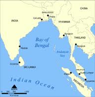
The Geo-Strategic Locations of Gwadar and Chahbahar:
Gwadar- the all-weather high value mammoth deep sea port is located on the Arabian Sea coast in South-western Baluchistan, bordering Afghanistan to the northwest and Iran to the southwest, just on the opposite end of the Gulf of Oman and the Strait of Hormuz. The strategic location of Gwadar port is only 180 km to the East from the mouth of the Straits of Hormuz and 72km from the Iranian border. The Strait of Hormuj- the 34 mile wide crucial energy route is one of the most strategically important chokepoints through which about one-fifth of the world’s oil, loaded with 17 million barrels of crude pass in one day. Gwadar is the third deep sea port of Pakistan after Karachi and Bin Qasim port. It was first identified by Pakistan as a port site in 1964. Comprehensive steps were taken in 2001 toward making the idea into reality when Pakistan’s biggest partner China extends its hand to fund the project. On March 22, 2002, Chinese Vice premier, Wu Bangguo, had flown to Gwadar to lay its foundation.
However, the US’s launching of “war on terror” and subsequent intervention in Afghanistan in late 2001, in the backyard of China, pushed Beijing back from its involvement in Gwadar. Since the western China was already ringed up by US bases in Central and West Asian countries, the new bases in Afghanistan sent an alarming signal to China’s political elites. Later China again took the port after Singapore Port Authority (SPA) and its partners exit for the tussle between Pakistan government and its navy for transferring land to the Singaporean authority around the port.
One the other hand, the strategic location of Chahbahar port is on the Makran Coast of the Sistan-Baluchistan province of Iran, only 72km (44 mile) from Gwadar port of Pakistan. The name Chabahar comes from the words char (four) and bahar (spring), meaning that the port has four seasons of springtime.
Two decades ago, in 1992, the Iranian government designated Chabahar as a special economic zone to allow potential investment from the outer world. Ten years ago, in 2003, India, Iran and Afghanistan first signed the Chahbahar port project. Iran agreed to connect Chahbahar to the Afghan border through highway network and India to build a 200km-long road from the border to Zarang/Delaram, which is on the Kandahar-Herat highway, to connect western provinces of Afghanistan. India has already completed the road from its part. It offers the landlocked Afghanistan an alternative way to truck the goods from Iran and to let up its dependence on Pakistan’s Karachi port. Apart from that, India and Iran are also working for a two major railroad networks which will take another decade to finish.
A Race for Dominance
By developing new ports and making strategic relationships, India and China are chasing each other and trying to settle the unsettled regional issues. To diversify trade resources and multiply access points, the new emerging economic superpowers, China and India, are trying to expand their sphere of influence from the regional playground to the global space.
The question arises that why China has invested heavily in Gwadar port and the roads linking it. It has many answers; one of the motivations may be that China does not have any hot water port which can be used all around the year. But the most pressing motivation is its strategic location. The Shanghai port is too far away from China’s main industrial bases, approximately 16,000 km, and it costs huge amount in terms of taxes and duties. On the other hand, the land route to Gwadar port is at a distance more than 2,500 km from China. The distance from western city of Kashgar, in the Xinjiang Uyghur autonomous region, to China’s east coast ports is 3,500 km, whereas the distance from Kashgar to Gwadar is only 1,500 km. So it is evident that instead of shipping through the Malacca strait, transporting goods from Gwadar to China is beneficial for both the countries.
China financed more than 80 percent initial expenditure of $248 million for the Gwadar port. Instead of passing through the Malacca strait, the Chinese Achilles heel, China wants to ship all its goods from the Gulf to the Indian Ocean, drop off at Gwadar and from there the supplies would be trucked through Karakoram Highway via khenjerab pass to Xinjiang then up to Shanghai. China has been investing in karakoram highway since the 70s, which actually gets its relevance now in the context of new geo-strategic environment.
According to the geo-political analysts, the takeover of Gwadar port of Pakistan by China is seen as part of China’s ‘string-of-pearls strategy’, a term used by United States to portray China’s oceanic influence from the South China Sea through the Indian Ocean and on to the Arabian Gulf. The geo-strategic location of Gwadar port will serve China to use it as a “listening post” to keep an eye on the ships passing through Hormuj Strait and “monitor US naval activity in the Persian Gulf, Indian activity in the Arabian Sea, and future US-Indian maritime cooperation in the Indian Ocean”, according to Zia Haider, an analyst at the Washington-based Stimson Center. He also said that the Gwadar port provides China “a transit terminal for crude-oil imports from Iran and Africa to China’s Xinjiang region”.
On the other hand, India is blessed with a geography that gives it the primacy in the Indian Ocean after the United States. But it does not go unchallenged by regional rivals like China. In 1994, the Chinese defense minister Chi Haitan openly challenged India’s primacy in Indian Ocean by saying that “the Indian Ocean is not India’s ocean.”
The Chinese presence near the Hormuj strait and Sino-Pak convergence of interests sent an alarming signal to India which is reflected in the Indian Naval Chief Suresh Mehta’s speech in 2008 that Gwadar port has “serious strategic implications for India”. “Being only 180 nautical miles from the exit of the Straits of Hormuz, Gwadar, being built in Baluchistan coast, would enable Pakistan take control over the world energy jugular and interdiction of Indian tankers,” he added.
Though India has strong Naval presence and a watchful eye in the Malacca strait that lies in the northern Indian Ocean but the weak point for India is that geographically India controls no strategic chokepoint in the sub continental coast through which international ships must pass.
Fearing Sino- Pak cooperation in the Gwadar port, India takes Chabahar port as a leverage to counter China’s influence and as a gateway to central Asia. Both India and Afghanistan has strategic partnership with the US, so getting support from the US about working with Iran was thought to be difficult. But India and Afghanistan managed to get a tacit support from the United States of the agreement on the development of the Iranian Chabahar port. Victoria Nuland spokesperson of State Department told the reporters that “these three countries are neighbors. They have to get along. We are obviously interested in increased trade and commerce back and forth there. So anything that ameliorates that situation is something that we would support”. The statement from the United States has come in a time when the diplomatic frictions with Iran is increasing and the West is working hard on making economic sanctions effective against Iran.
However, few have noted the fact that, on the sidelines of 16th NAM summit, the three countries like India, Iran and Afghanistan had a meeting to boost ties and increase trade cooperation among them. On the Iranian side Abbas Araqchi, the deputy foreign minister for Asia-Pacific affairs, Afghanistan by its deputy foreign minister Abdul Hai Haidar and India by its foreign secretary Ranjan Mathai sat together for joint cooperation in the Chabahar Port specifically for development and expansion of trade, transit and investment. The three parties have agreed to a meeting of their representatives within three months in the port city.
The strategic position of India, Afghanistan and Iran and their convergence of concerns and interests pushed them to cooperate for greater geo-political and geo-economic interests. India views Iran and Afghanistan as an opportunity to attain its foreign policy objectives. For this reason, India is using Afghanistan as a bridge to connect itself with Central Asia and to promote “Connect Central Asia” strategy. The idea of “Connect Central Asia” strategy suggests increased economic cooperation with the Central Asian region and concomitant political and strategic penetration. The long diplomatic effort over the Turkmenistan-Afghanistan-Pakistan-India (TAPI) natural gas pipeline project is the most evident sign of such an approach. New Delhi also holds its first foreign military base in Tajikistan, the Farkhor Air Base, which is sometimes called Ayni. The base is jointly operated by the Indian Air Force and the Tajikistan Air Force. Ten years ago, India rebuilt and renovated the base at a cost of US$10 million. India is now planning to connect other regional countries like Turkmenistan, Kazakhstan, Uzbekistan, Kyrgyzstan, and Tajikistan through establishing fourteen flights to increase trade cooperation.
Concern around the Ports
Both Baluchistan and Sistan-Baluchistan, where the two ports are located, is a strategic treasure for Pakistan and Iran consecutively, but they can also be a time-bomb. It depends on the way how these two regions are handled by the states. Baluchistan is already a hotbed of rivalry where the state and non state forces are continuously fighting with each other. In Sistan-Baluchistan, the Sunni insurgents are very active and using this region as a launching pad for their operation in Shiite Iran. The topography of these two regions, the security panorama and the availability of weapons are the factors that pose a big challenge to run the ports effectively. Moreover, China’s policy against the Uighur Muslim majority of Xinjiang put them in a vulnerable position in Baluchistan. Another thing is whether Pakistan will allow China’s naval ships and its navy in Gwadar area is not clear. And the Infrastructural works both in Chahbahar and Gwadar is very slow which raises many questions regarding the seriousness of the countries involved.
The writer is a freelancer